Thursday, August 21, 2014

Probabilidad de un evento significativo de lluvias en Puerto Rico mañana (INVEST 96L)

Onda tropical (designada INVEST 96L) se acerca a Puerto Rico con probabilidades de generar cantidades significativas de lluvias en toda la isla...

Imagen actualizada del Viernes a las 10:56am:


El sistema es amplio, de características monsónicas (Ejemplos en el Pacífico Occidental) y cargado de mucha humedad dado el influjo masivo de aire húmedo en su cuadrante sureste.


Radar de Antillas Francesas:


Radar de Cayey:


Algunos modelos de mesoescala con resolución alta sugieren que el monto mayor de lluvias en Puerto Rico podría ser mañana en la tarde/noche, una vez INVEST 96L se comienze a alejar...

Esto es explicado por un aumento en la convergencia de humedad y un influjo masivo de aire sumamente húmedo desde el sureste. 


El modelo global GFS propone de 3-5 pulgadas en casi todo el pais. A esta resolucion baja de 27km podemos concluir que cantidades mayores son definitivamente posibles, especialmente cuando introducimos el factor de las montañas en la generación de lluvias. 


Modelo de mesoescala NAM (12km) pone aguaceros generalizados sobre la isla mañana en la tarde:


Pero el evento puede tornarse significativo en la tarde/noche hacia el sábado en la madrugada, cuando una banda alimenticia (feederband) podría llegar a traer lluvias en "trenes" que podrían generar acumulaciones mayores, especialmente en las laderas sur de la Cordillera Central. El potencial de un evento masivo de lluvias e inundaciones esta latente. Ojo cuando el eje se aleje de Puerto Rico.

Feederband sobre Puerto Rico? Recordamos que es solo un modelo y una simulación:


Hay una VIGILANCIA DE INUNDACIONES en efecto para todo Puerto Rico...


Sigan los boletines oficiales del Servicio Nacional de Meteorología en San Juan:
Click aqui para SNM San Juan

Muy pendientes a cualquier eventualidad. Este sistema puede acabar de rematar a la sequía en los embalses, pero también puede generar muchos problemas con inundaciones...


Greensboro, NC (8/22/2014)        12:21 am

INVEST 96L - Broad circulation, slow development and rainmaker for drought-stricken Puerto Rico

INVEST 96L is nearing the Lesser Antilles...


Heavy rainfall and some strong winds are possible...

Tropical cyclone development will be slow due to the large nature of this system. Detachment from the ITCZ occurred, this being reflected in the markedly poleward track of today. 

Vertical wind shear remains low, with an upper-level ridge nearly collocated with the low, thus favoring outflow development for deep convection:


SAB Dvorak estimates are of 1.0/25kts. 

An ASCAT pass revealed the elongated surface circulation associated to this system. This represents a hindering factor for any significant intensification. Any deepening trend will be slow, as long as the broad circulation remains elongated an coarse. 


Later down the road, significant land interaction is possible if INVEST 96L ends up passing directly over Hispaniola. This will be determinant in the future intensity of the system

In terms of track, it appears that the trough I mentioned in the past two blog posts (check archive) will be strong enough to erode the Bermuda High in its western quadrant. This will open weaker steering currents and a more northwestward track of INVEST 96L. Should it intensify, a recurvature east of the US coastline will be a plausible scenario. The weaker the system, the more westerly the track will be in response to the low-level tradewinds. It will all depend on its eventual intensity. 

For the moment, it seems like a strong tropical wave with heavy rainfall at times and some gusty winds will be affecting the Leeward Islands and Puerto Rico tomorrow. Any development into a tropical depression or even weak tropical storm won't represent a major change in this forecast. Similar conditions to those in BERTHA are possible, though this system might bring more rain and strong winds due to its larger size. 

Trackwise, a NW track near Puerto Rico, then near Hispaniola or just to its north, towards the Bahamas seems like the most likely one, for now. 

12Z Guidance:


INVEST 96L may follow a similar track to BERTHA a few weeks ago. Climatologically speaking, storms do repeat tracks from their predecessors in a same hurricane season.

BERTHA's track:

Greensboro, NC (8/21/2014)  1:47pm


Wednesday, August 20, 2014

INVEST 96L - Land & Trough interactions will determine INTENSITY and TRACK

Idioma/Language: English

Weaker forecast solutions become likely as INVEST 96L nears the Antilles...

INVEST 96L organizing east of the Lesser Antilles... Latest satellite images hint at the development of a closed circulation, in part thanks to a very strong interaction with southwesterly low-level moist inflow into the system. It has the characteristics of a monsoonal type system, such as many examples in the Western Pacific Ocean. Its large, broad, and directly attached to the ITCZ, for now.

Large systems struggle to organize internally, they usually do it at a slower pace, but are more robust than their smaller counterparts. The strong SW inflow will keep the source of moisture and instability, thus favoring deep convective development. 

As for now, a strong surge of southwesterly inflow converging into the wave axis may favor an ITCZ break-up and developing a low pressure with the possibility of cyclogenesis. This may be happening near 12N, 51W. We have to wait and see.


The most recent ASCAT pass also shows the strong southwesterly inflow and the axis of the ITCZ directly interacting with INVEST 96 (below):


Models: Intensity and track forecasts


A shift towards the north with a weaker storm (not even storm in some cases) has trended in recent runs. As I write this, the 12Z GFS run is coming out, with a weaker storm and a more NW track.

This track to the NW is explained by a deepening mid to upper-level trough that will emerge off the US east coast and erode the ridge in the Western Atlantic, thus favoring a more northerly track, even recurvature. Such track will imply significant land interaction with islands, such as Hispaniola with 10,000 ft mountains. This may influence on the system, with the potential of disrupting the hypothetical circulation enough to dissipate it, if it develops into a weak/moderate storm. 

The trough that may influence INVEST 90L's potential track is currently located over the Great Lakes (below):

data/nam/12/nam_namer_000_500_vort_ht.gif

The influence of this trough may be enough to make the system turn NW, but may not be enough to make it recurve. Its difficult to tell at the moment. Evidently, guidance is currently showing a S. Florida threat, for now. This is likely going to keep changing... The never-ending business of model analysis and guessing. 

An upper-level ridge will move close to the system and will provide a relatively favorable environment in terms of shear.  

The European model (ECMWF) has insisted in little to no development of INVEST 96L... A very reliable model needs to be taken into consideration. In its 00Z run, ECMWF hinted that it will be a wave crossing through the Greater Antilles and emerging into the Gulf of Mexico, maybe closing a low before landfall near Louisiana more than 200 hours away.

Anywhere from the Gulf coast, to North Carolina, to even a total recurvature east of the US are within the cone of possibilities of INVEST 96L. 

That said, there are lots of uncertainties, and we can only conclude that a tropical wave with potential of tropical cyclone development will be near the Lesser Antilles and approaching Puerto Rico in two days. 


Greensboro, NC (8/20/2014)  12:43pm

Tuesday, August 19, 2014

Potential development east of the Antilles - CRISTOBAL in the making?

Idioma/ Language: English

Two tropical waves east of the Antilles show promise, with one having the potential of becoming a newsmaker...

Satellite and surface observations indicate that there are two disorganized clusters of convection associated to two tropical waves east of the Lesser Antilles. These are embedded directly in the ITCZ, thus halting any quick tropical development for the time being. 


The waves are interacting directly with the ITCZ. The likelihood of tropical depression of storm formation soon is LOW, for now (see below): 
An overview from CIMSS data products reveals that upper-level winds are relatively favorable, with shear of less than 15 kts in the area. An upper-level ridge is present near 12N, 45W, and its expected to track westward close to our system of interest. The upper-level low NE of Puerto Rico is expected to slowly track westward, away from the wave. This may be key in the possible tropical cyclone development once it nears the Caribbean in two to three days


Saharan Air Layer (dust) is expected to lessen its burdening effects, when compared to a few weeks ago. This means there will be a more significant amount of instability present in the environment, especially as our system moves further west. However, it is an inhibiting factor at the moment for tropical cyclogenesis to happen (see below). 


Track an intensity prospects:

Lots of discrepancies past Puerto Rico...

It does seem like this system may have the potential of becoming a significant threat to land (e.g. Antilles and US coastline). Numerical models agree on a general WNW track that may bring the disturbance over the Caribbean Sea, just south of Puerto Rico, then slowing down and turning NW in response to a weakness in the ridge near Florida/Bahamas. The ridge to its north will be eroded by a trough that will emerge off the eastern seaboard. This trough is currently located over the Northern Plains (see below). 

data/nam/12/nam_namer_000_200_wnd_ht.gif

Despite the effects of this trough, it appears that it wont be enough to make CRISTOBAL (?) recurve away from North America. A general NW track seems more plausible, due to the presence of a weak ridge (500mb) over the Dixie Alley. That said, the potential of a Gulf coast tropical storm or hurricane threat early next week is within the realm of possibilities, as of now. 

Intensity-wise, things are far more complicated than with track. Its intensity will depend on many factors that are hard to forecast at this moment, such as: 

1) Land - effects of land interaction (e.g. if it passes over 10,000 ft mountains in Hispaniola)
2)Stability - how much dry air will entrain in its structure
3 Shear  - vertical shear (which appears to be quite favorable) 
4) Other potential structural changes that may or may not favor intensification.  

Personally, I consider this system to have a decent chance of becoming a hurricane at some point, if it develops. Despite this, we have plenty of time to track it

Models vary their track from a Louisiana/Mississippi hit called by 12Z GFS and CMC global models, to a recurvature just east of Florida by the 12Z NAVGEM (Navy global model). The strength of the trough and its extent to the south are the drivers of the different model track solutions

For reference, attached is an image of the 12Z GFS that Brian McNoldy (RSMAS/Miami) adapted showing the forecast track for this solution:


It is way to early to tell, plenty of time to observe.

For now, it can be said that a strong tropical disturbance, perhaps a tropical storm, may be near Puerto Rico (likely to the south) near Friday, and moving across the Caribbean during the weekend. 

Greensboro, NC (8/19/2014)  1:44 pm

Friday, August 15, 2014

Tropical waves in the Atlantic - An overview of the conditions

Idioma/ Language: English 

Two tropical waves stand out in an otherwise, very quiet Atlantic Ocean...

Satellite and surface observations show that a low pressure system is associated to a tropical wave in the eastern Atlantic Ocean. A strong influence of the ITCZ on the south side of the system is noted in visible satellite images. 


12Z OPC Analysis shows the tropical wave passing 30W with a 1012 low pressure embedded in the system. 


A 1602Z ASCAT pass revealed a closed circulation and some (potentially contaminated) 30kts vectors. 


In fact, buoy observations near the system shows westerly winds of 23kts south of the low and easterly winds to its north. The circulation is indeed well-defined and broad, but lacking any deep convection near the center. 


Vertical shear is weak to moderate, out of the east with a magnitude of 5-15 kts in the area, per CIMSS:


It appears that a strong upper-level low will inhibit any chances of this system to develop into a tropical cyclone as it heads towards the Caribbean. In fact, none of the global models analyzed for this post (GFS, ECMWF, FIM, CMC & NAVGEM) show development of this system due to strong shear and lots of dry (stable) air in its environment. 

Notice the strong upper-level low forecast by the GFS to be present just east of the Antilles in 3 days.


This system will be monitored, but it appears that it will be another wave to its east the one to be watched for tropical cyclone development in a few days. For now, the Atlantic remains quiet in a particularly hostile Atlantic Hurricane Season 2014.

The tropical wave to its east has a better chance of formation:


Greensboro, NC (8/15/2014)   12:37pm

Wednesday, August 13, 2014

JULIO, KARINA & Invest 90E - East/Central Pacific hurricane basins remain active, the Atlantic stays out of the game

Idioma/ Language: English 

More tropical cyclone activity east of the Dateline in the Pacific Ocean, currently a Hurricane and a Tropical Storm are active...

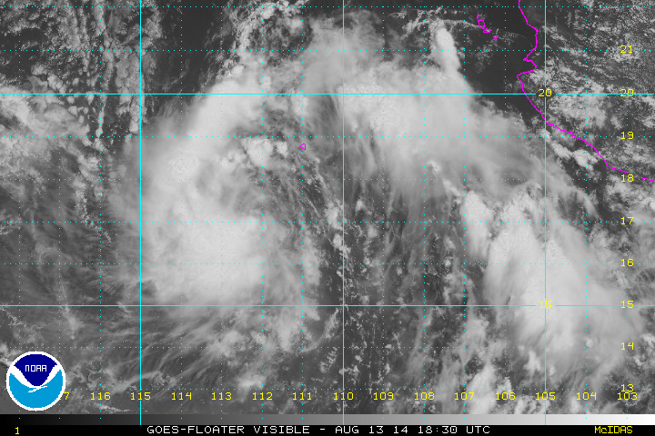
Hurricane JULIO (75mph), Tropical Storm KARINA (40mph) and Invest 90E are the main players in the East/Central Pacific hurricane basins...

Image below adapted from NOAA


Hurricane JULIO has regained its strength, now with estimated sustained surface winds of 75mph (Category 1), while over open waters of the Central Pacific Ocean, and under warning responsibility of the Central Pacific Hurricane Center (CPHC - RSMC Honolulu). JULIO is one of the few storms on record to have maintained hurricane intensity north of 30N in the Central Pacific in recorded history. In fact, Brian McNoldy found that only 6 storms have previously achieved this milestone, making JULIO the 7th in that elite. The storm should move slowly northeastward until dissipation occurs, far from land. 

Hurricane Julio 75mph (Source: NASA) 


Hurricane JULIO has been moving over higher-than-normal sea surface temperature (SST) anomalies. In fact latest NOAA analysis shows anomalies of no less than 1.5 deg Celsius where the hurricane is located. This has certainly been a favorable factor in JULIO's remarkable achievement.


Newly-born Tropical Storm KARINA does not represent an immediate threat to land. It is expected to move away from Mexico and into open waters of the Pacific Ocean. It may also end up crossing the 140W longitude to enter the CPHC responsibility area, as also did GENEVIEVE, ISELLE and JULIO. This storm may show some interesting interactions if another system later forms to its east, potentially forcing some Fujiwara interactions over open waters (per 12Z August 13 GFS run). This is a long shot, but worth watching if it happens. For now, it does not appears that KARINA will directly threat the Hawaiian Islands.
KARINA should become a hurricane (per NHC forecast). A limiting factor in KARINA's potential intensity will be the cold wake left by hurricane JULIO in the area (see image above). These cooler SSTs may also be related to a more stable marine environment, unfavorable for sustained deep convection. Otherwise, vertical shear should remain relatively low, this favoring upright vertical structure and intensification. 

Tropical Storm KARINA 40mph (Source: NOAA)


12Z Guidance for Tropical Storm KARINA


Another system named Invest 90E may track near to the south of Hawaii and develop into a tropical storm or Hurricane. CPHC grants it a 30% chance of development within the next 48 hours. 12Z guidance takes it in the general direction of the islands, while global models like the GFS and CMC take the system to their south. Interestingly, ECMWF makes this an intense storm and moves it close to the east of the Big Island while later recurving without direct hit. The FIM 15km model takes it just south in an almost direct hit. Lots of uncertainty this early in the game. For now, it can be said that: This system could be of interest for the Hawaiian Islands in about 5 days.


The Atlantic Basin remains quiet... GFS model shows a potential Cape Verde storm in a week. Lots of time ahead to watch that one. For now, lets keep our eyes where the action is, the Pacific Ocean.

Greensboro, NC  (8/13/2014)  3:18pm

Sunday, August 10, 2014

Invest 94L - On its potential development and track towards the Caribbean Sea

Idioma/ Language: English 

My first blog post!

A strong tropical wave has emerged off the West African coast and has been designated as INVEST 94L...

The system looks to be of a potential long-track across the Caribbean Sea, typical for mid-August, a so-called "straight runner"

NOAA/OPC 12Z Surface Analysis shows a 1011 mb surface Low pressure associated to this system. It is still interacting directly with the ITCZ and has a tropical wave associated to it. A 1027 mb High pressure system to its north will guarantee a general westward track throughout the next few days. 


Its structure is broad and disorganized, with convection occurring near the Cape Verde Islands, south of 10N in the ITCZ, and the African coast.  Source: NOAA


Easterly vertical wind shear of 10-20 kts is currently impinging on the low, which is quite normal in this location and time of the year. Source: CIMSS


.

Saharan Air-Layer analysis from CIMSS shows lots of dry air surrounding 3 out of 4 quadrants of INVEST 94L. This dry air will be a limiting factor for early development into a tropical depression or tropical storm. Conditions should slowly improve as it moves away from Africa. Source: CIMSS


An ASCAT pass shows partially the circulation associated with the low, with winds that are generally of less than 20kts. Source: NOAA


Model guidance agrees on a westward track towards the Caribbean Sea. It is still very early to tell on track and intensity, but the potential of this system becoming a tropical cyclone is decent. 


The only global model picking up on its formation is the GFS, which hints at a W/WNW track through the Caribbean Sea and towards the Yucatan Peninsula by Friday (August 22). It is way too early but this type of track is within what can be expected from tropical cyclones in the Atlantic this time of the year. At this stage, we are merely speculating


A recent historical track is an extreme case, Hurricane Dean (2007), which became a Category 5 in the Caribbean Sea and is the last Category 5 landfall on record in the Atlantic Basin. This doesn't mean our storm will behave even similarly, but it shows what could happen in the Caribbean during this time of the year. 


Many days ahead, many days to track this system. Let the fun of tropical cyclogenesis, track, and intensity forecasting begin!

Greensboro, NC  (8/10/2014)  5:48pm